Evidence: Insufficient data Explanation: Not enough data yet
Giant SOS at French-Swiss border lake: what the vanishing water really shows
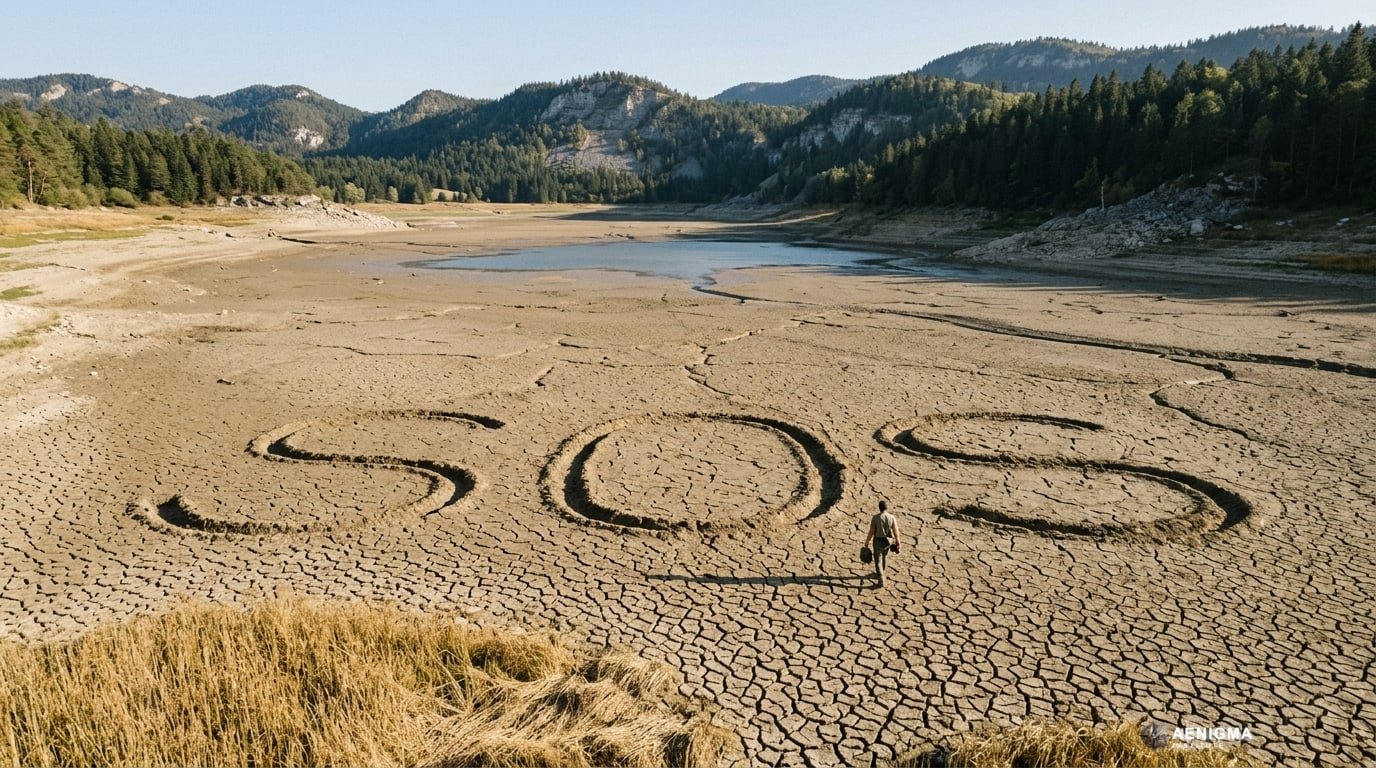
A giant "SOS" message has appeared on the dry bed of a lake along the French-Swiss border, highlighting a severe loss of water. While drought is a clear factor, the region's highly porous karst geology plays a crucial role in how surface water disappears into underground cavities.
Why AENIGMA is covering this
Understanding the dynamics of disappearing lakes in karst regions is crucial for grasping the broader hydrological challenges facing mountainous borderlands. These water bodies are not just scenic landmarks; they are integral parts of a complex, interconnected water cycle that supports local ecosystems, agriculture, and human consumption. When a lake vanishes so dramatically, it signals a significant shift in the regional water balance that can have cascading effects on the surrounding environment. The intersection of changing weather patterns and vulnerable geological formations creates a unique environmental pressure point. Karst landscapes act as natural amplifiers for drought conditions, turning a lack of rain into a rapid and highly visible loss of surface water. Detailing this geological mechanism provides essential context for why certain regions react so drastically to dry spells, moving the conversation beyond simple weather observations to a deeper understanding of earth sciences. By examining cases like the giant "SOS" on the French-Swiss border, we gain insight into the fragility of seemingly permanent natural features. It highlights the necessity of looking beneath the surface to understand environmental changes. This approach ensures that discussions about water scarcity and landscape transformation are grounded in both meteorological data and the fundamental geological realities of the earth, providing a complete picture of our changing natural world.
What happened
A massive "SOS" has been traced onto the exposed bed of a lake situated on the border between France and Switzerland. This striking message serves as a stark visual indicator of the water body's dramatic recession during a period of intense dryness. The event was documented and broadcast by France 24, bringing international attention to the rapidly changing landscape of the border region. The lake bed, normally submerged under meters of water, is now exposed to the open air, revealing cracked earth and a completely transformed environment. Residents and visitors have witnessed the shoreline retreating significantly over a short period, leaving behind stranded aquatic habitats and dry docks. The creation of the giant "SOS" underscores the deep local concern over this rapid environmental shift. Such visual appeals often occur when communities face sudden or severe alterations to their familiar natural surroundings, serving as a grassroots method of drawing attention to environmental distress. The message highlights a period of intense dryness that has fundamentally altered the local geography. This visual phenomenon brings immediate focus to the physical state of the lake, prompting questions about the underlying mechanisms driving this rapid loss of water. While the lack of rain is the most visible trigger, the speed and scale of the water's disappearance point to complex interactions beneath the surface. The appearance of the message has transformed a quiet natural event into a highly visible symbol of hydrological vulnerability in the region.
What we know
The border region between France and Switzerland is largely defined by the Jura Mountains, a sub-alpine mountain range built predominantly of limestone. This specific type of rock is highly susceptible to chemical weathering, leading to the formation of what geologists call a karst landscape. Karst environments are characterized by complex underground drainage systems, sinkholes, and extensive cave networks. Over millions of years, slightly acidic rainwater naturally dissolves the calcium carbonate in the limestone bedrock. This slow but relentless process widens natural fractures, eventually creating large subterranean conduits and caverns. Surface water in these regions does not always stay on the surface; it frequently finds its way into these underground channels. When a lake sits atop a karst system, its bottom is rarely a perfect, impermeable seal. Instead, the lake bed often contains fissures and swallow holes, known geologically as ponors, which act like natural drains. Under normal conditions, the inflow from rivers, streams, and regular rainfall exceeds or matches the rate at which water escapes through these geological drains, keeping the lake full and stable. During periods of low precipitation, this delicate balance shifts dramatically. The inflow of fresh surface water drops, but the underground cavities continue to draw water away from the lake bed. This geological reality means that lakes in karst regions are inherently more volatile than those sitting on impermeable bedrock like granite or clay. They can experience rapid fluctuations in water levels, sometimes draining almost entirely when surface replenishment fails to keep pace with the subterranean outflow. The Jura region is a classic example of this topography, providing the very name for the Jurassic period due to its extensive limestone formations.
What we don't know
While the general mechanics of karst geology are well understood, the precise hydrological equation for this specific lake's current state remains incomplete. There is insufficient data to definitively separate the exact percentage of water lost to surface evaporation versus the volume drained through subterranean fissures. Hydrological systems in limestone mountains are notoriously difficult to map with absolute precision, as the underground networks are vast, complex, and largely inaccessible to direct observation. It is also not fully known how the current dry spell compares to historical cycles of drought in this specific micro-region over the scale of centuries. Karst lakes are known to have dried up in the past, long before modern climate monitoring began. Determining whether this recent disappearance is an unprecedented anomaly driven entirely by modern shifts, or part of a rare but natural historical cycle, requires deeper paleoclimatological data that is not currently available for this specific event. Furthermore, the exact pathways of the underground water once it leaves the lake bed are often a mystery. Subterranean rivers can travel for dozens of kilometers before resurfacing at a lower altitude as a karst spring. Without extensive and recent dye-tracing studies specifically targeting the active fissures in this lake bed, the final destination of the drained water cannot be stated with certainty. The exact capacity of the underlying aquifers and how quickly they might recharge once the rains return also remain open questions.
What is claimed
The primary explanation for the lake's disappearance points to a dual mechanism involving both weather and geology. It is proposed that a combination of severe meteorological drought and the region's specific karst geology is responsible for the rapid loss of water. According to this model, the lack of rainfall starves the lake of its usual surface inflow, while the porous limestone bedrock actively drains the remaining water away into deep underground cavities. This explanation suggests that the lake is essentially being emptied from below while being denied replenishment from above. The underground cavities, which normally act as a hidden extension of the lake's volume, become a primary sink when the regional water table drops. As the groundwater levels fall due to the extended drought, the suction effect through the fissures in the lake bed likely increases, accelerating the drainage process. This dual-factor model is considered a highly possible explanation for the sudden and dramatic exposure of the lake bed. It aligns perfectly with the known behaviors of water bodies situated in the Jura mountain range. The giant "SOS" is therefore seen not just as a reaction to a hot summer, but as a response to a complex geological and climatic interaction where the very ground beneath the lake contributes to its disappearance.
What is verified
It is a verified fact that a giant "SOS" was created on the dried bed of a lake on the French-Swiss border, an event documented and reported by the news outlet France 24. The visual evidence of the lake's severe recession is clearly captured in these reports, showing dry, cracked earth where water usually sits. The physical absence of water in areas that are typically submerged is an observable reality that has impacted the local landscape. Geologically, it is an established scientific fact that the French-Swiss border region, particularly the Jura Mountains, is dominated by karst topography. The presence of limestone bedrock, underground drainage networks, and the inherent permeability of the landscape are foundational elements of the local geography. The mechanics of how karst systems dissolve and drain surface water are universally accepted principles in the field of geology and hydrology. It is also verified that the broader region has experienced periods of significant drought, impacting surface water levels across various local ecosystems. The combination of these verified elements—the visual drying of the lake, the documented news reports, and the established geological framework of the region—forms the baseline of our current understanding of the event. The underlying vulnerability of karst lakes to dry spells is a documented characteristic of this specific geographic zone.
Competing explanations
- Possible: The lake's disappearance is caused by a combination of severe drought and the region's karst geology, which allows surface water to drain into underground cavities.
What would change our assessment
To move beyond the current status of insufficient data regarding the exact mechanics of this event, hydrologists would need to conduct comprehensive, long-term monitoring of the specific lake basin. This would involve installing a network of piezometers to measure the exact fluctuations of the underground water table in real-time. Comparing these subterranean levels directly with surface evaporation rates and local rainfall data would clarify the exact mathematical balance of the water loss. Extensive dye-tracing experiments would also be required to map the subterranean flow. By introducing harmless fluorescent dyes, such as fluorescein, into the remaining water or known sinkholes, researchers could track exactly where the water goes and how fast it travels through the karst network. This would map the hidden plumbing beneath the lake, confirming the capacity, direction, and flow rate of the underground cavities drawing the water away. Additionally, a detailed analysis of historical climate records and sediment cores extracted from the lake bed could provide essential context. If deep sediment layers show that the lake has dried up completely multiple times over the past millennia, it would frame the current event within a natural, albeit extreme, geological cycle. Conversely, if the core samples indicate continuous water cover for thousands of years without interruption, it would strongly point to a modern, unprecedented climatic shift driving the current disappearance.
Sources
- France 24 (supports, primary)
Protocol AENIGMA-EF-0.1