Evidence: Unsubstantiated Explanation: Not enough data yet
Noah's Ark at Durupinar and what the new soil samples really show
Recent media reports indicate that 1,000 samples have been collected from the Durupinar site in eastern Turkey to analyze its composition, reigniting discussions about Noah's Ark. While popular claims suggest the boat-shaped formation is the remains of the legendary vessel, established geological consensus identifies it as a natural feature resulting from erosion and landslides, with no archaeological evidence currently supporting human construction.
Why AENIGMA is covering this
The AENIGMA Institute is covering the ongoing research at the Durupinar site because it represents a classic intersection of geology, archaeology, and popular mythology. The site provides a highly educational case study for contextualizing the difference between geophysical anomalies and confirmed archaeological features. Anomalies can easily be caused by natural moisture gradients or complex stratigraphy, and understanding this distinction is crucial for interpreting field data accurately. By examining how claims about the site are constructed and disseminated, we can highlight the critical importance of the scientific method in field research. Highlighting the established geological consensus regarding the natural formation of the site is essential to balance the popular mythological claims with evidence-based analysis. The public fascination with finding physical proof of ancient narratives often leads to the misinterpretation of natural landscapes. Covering this topic allows for a detailed explanation of how natural processes, such as landslides and differential erosion, can create topographical features that closely mimic human-made structures. This underscores the editorial mandate to separate what is observed from what is interpreted. In this case, the observation is a boat-shaped geological formation, while the interpretation is a mythological vessel. By focusing on the rigorous requirements of scientific verification, including controlled field observation and data transparency, this coverage aims to promote a deeper understanding of how earth scientists and archaeologists evaluate extraordinary claims. It demonstrates how the scientific community builds consensus based on verifiable data rather than visual similarities alone. The Durupinar site serves as a powerful reminder that the natural world is capable of producing extraordinary shapes and patterns. Appreciating the geological forces that sculpt our planet is just as fascinating as the ancient stories we seek to validate. Ultimately, our goal is to provide readers with the analytical tools necessary to navigate the complex landscape of historical claims, ensuring that enthusiasm for the past remains grounded in rigorous, evidence-first methodology.
What happened
A recent report from the verified Greek media outlet enikos.gr highlights ongoing field research at the Durupinar site in eastern Turkey. The coverage notes specifically that 1,000 samples have been collected from the location. The stated objective of this extensive sampling campaign is to analyze the material composition of the site to reveal what might lie hidden within or beneath the surface formation. Collecting 1,000 distinct samples represents a significant logistical undertaking in any field research endeavor. Soil and rock sampling in mountainous terrain presents unique challenges. The Mount Ararat region is characterized by high altitudes, rugged topography, and a climate that severely limits the window for fieldwork. Field teams must navigate steep inclines and unpredictable weather while maintaining the integrity of their grid system. In standard scientific practice, a sampling initiative of this scale requires systematic grid planning and precise topographical mapping. The site is typically divided into manageable sectors, allowing researchers to record the exact provenance of every piece of material collected. Researchers establish rigorous protocols to ensure that each sample is collected without cross-contamination. The process involves documenting the exact spatial coordinates, depth, and stratigraphic context of every individual sample before transport to laboratories for analysis. Each sample is carefully bagged, labeled, and logged into a central database. This maintains a strict chain of custody, ensuring that when a sample is tested months later, its exact origin on the site is undisputed. Field campaigns of this magnitude are typically multidisciplinary. They involve specialists in geology, geomorphology, geochemistry, and environmental science to ensure that the data collected is representative of the broader landscape. Currently, the evidence status regarding the findings of this specific sampling effort remains unsubstantiated, and the explanation status is categorized as insufficient data. This classification reflects the reality that collecting samples is only the preliminary phase of scientific inquiry. The subsequent phases require considerable time and resources. Laboratory preparation, chemical and physical analysis, data interpretation, and the drafting of formal reports are lengthy processes. Soil samples must often be dried, sieved, and chemically treated before they can be analyzed under microscopes or subjected to spectrometry. Until the results of these 1,000 samples are processed and synthesized, the specific material composition remains unknown. Any potential new insights regarding the Durupinar site have yet to be published and evaluated by the broader scientific community. The media report brings attention to the ongoing interest in the site, but the scientific process dictates that conclusions must wait for finalized data.
What we know
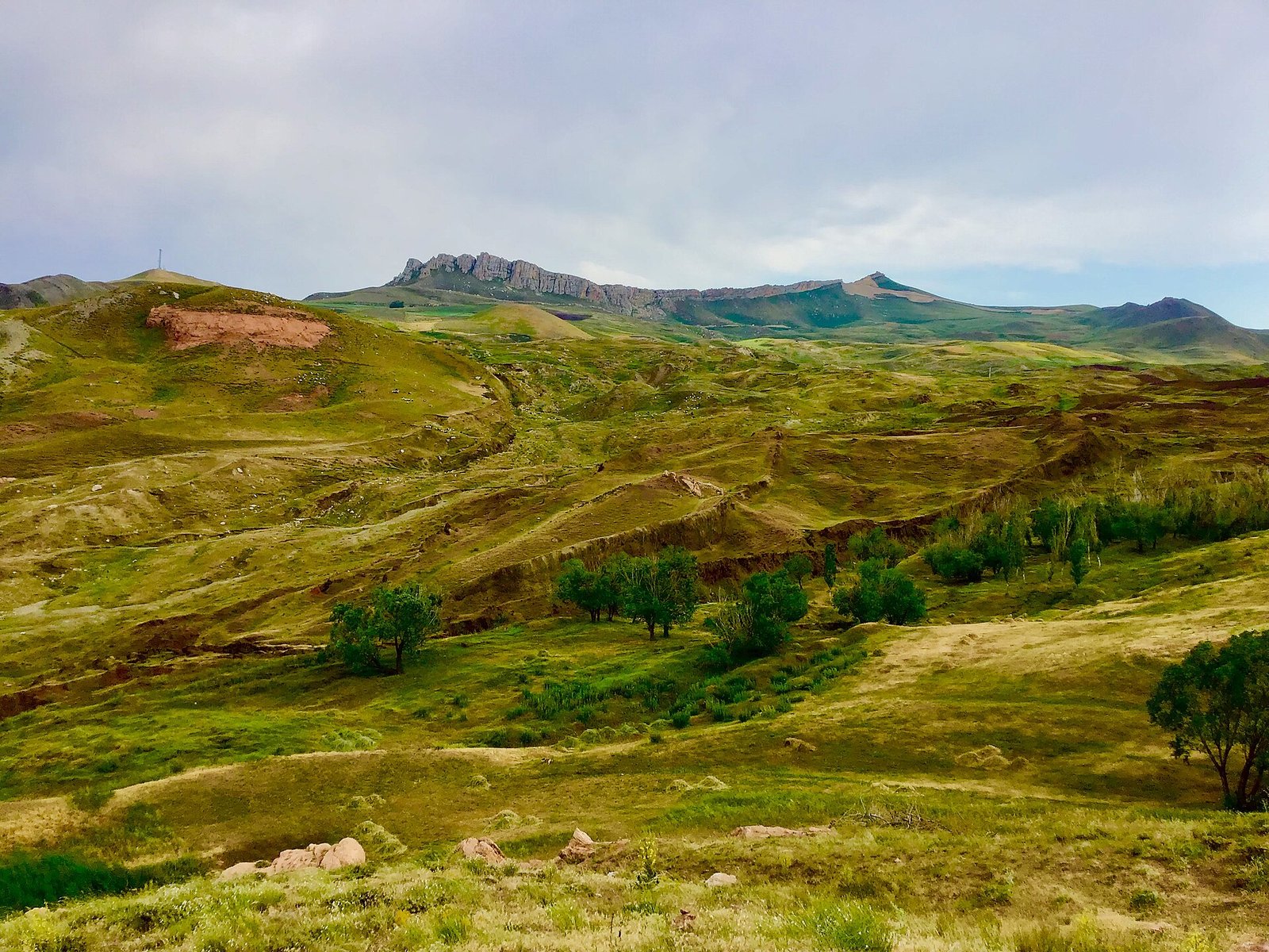
The Durupinar site is a distinct topographical feature located in the mountainous terrain of eastern Turkey. It is situated within the broader region associated with Mount Ararat, an area dominated by dramatic peaks and deep valleys. The most prominent characteristic of the site is its roughly elliptical, boat-like shape, which contrasts visually with the immediate surrounding landscape. This visual distinctiveness has made the site a subject of sustained public and media interest since it was first widely identified in mid-twentieth-century aerial photography. From a scientific perspective, there is an established geological consensus regarding the nature of the Durupinar site. Geologists propose that the boat-like shape is a natural formation resulting from a combination of erosion, landslides, and rock deformation. The Anatolian tectonic plate is caught between the converging Eurasian and Arabian fault lines. This immense geological pressure leads to frequent earthquakes and the uplifting of rugged mountain ranges across the region. Continuous tectonic activity fractures the bedrock, creating vast amounts of loose debris composed of basalt, andesite, and limestone. The region is characterized by complex geology and steep topography, creating an environment highly susceptible to mass wasting events. Mass wasting, such as mudflows and landslides, occurs when soil, rock, and debris move downslope under the influence of gravity, often triggered by heavy rainfall or seismic tremors. When these moving masses encounter more resistant bedrock outcroppings, the flow can bifurcate and move around the obstacle. The material eventually comes to rest in shapes that often exhibit bilateral symmetry. Over time, subsequent weathering and differential erosion further sculpt these deposits. Differential erosion happens when softer materials, such as loose clay and volcanic ash, wash away more quickly than harder, more resistant materials. This natural sculpting process leaves behind streamlined, aerodynamic, or boat-like forms that stand out from the eroded surroundings. The geological processes responsible for such formations are well-documented in mountainous regions globally. The phenomenon of pareidolia plays a significant role in how such geological features are interpreted by non-specialists. Pareidolia is the tendency of the human brain to perceive familiar patterns or objects in random or natural stimuli. It is an evolutionary trait that allows humans to recognize faces and shapes quickly, but it frequently causes observers to see artificial structures in natural landscapes. When viewed from specific angles or in aerial photographs, the natural symmetry of the eroded landslide deposit at Durupinar strongly resembles the hull of a large vessel. This striking resemblance has led to its widespread recognition and the enduring fascination it commands. Structural geology and geomorphological mapping of the site and its environs consistently indicate a natural origin. The materials present and the forces that shaped them are entirely consistent with the regional geological history of eastern Anatolia.
What we don't know
We do not know the specific results, chemical compositions, or physical properties of the 1,000 samples mentioned in the recent media report. This data has not yet been published in scientific literature. The exact methodology employed during the sampling process is also not detailed in the provided facts. In field research, there is a significant difference between surface soil sampling, shallow augering, and deep core drilling. Surface samples can only reveal the composition of the most recent depositional layers. These upper layers are often heavily weathered and mixed by modern environmental factors, including wind, rain, and local agricultural activity. Deep core drilling, by contrast, extracts intact columns of earth that preserve the chronological sequence of geological events over millennia. We do not know the depth from which these samples were extracted, nor do we know the specific laboratory techniques that will be applied to them. Standard geological and archaeological analyses might include thin-section petrography. This technique involves slicing rock or soil samples thin enough for light to pass through, allowing researchers to examine mineral structures under polarized light to determine their origin. Researchers might also use X-ray fluorescence to determine the elemental composition of the soils, identifying specific concentrations of metals or minerals. Micromorphological studies could be employed to understand the microscopic processes of soil formation and distinguish between natural sedimentation and human activity. Because we do not know which of these methods are being utilized, we cannot anticipate the exact nature of the data that will eventually be produced. Furthermore, we do not know the deeper subsurface stratigraphy of the Durupinar formation with absolute certainty. Stratigraphy is the backbone of both geology and archaeology. It relies on the principle of superposition, which states that older layers of earth are generally found beneath younger ones unless disturbed by later events. Without knowing the exact stratigraphic context of each of the 1,000 samples, the chemical data loses much of its meaning. Surface mapping and regional geology provide a robust framework for understanding the site as a natural landslide feature. Detailed, high-resolution stratigraphic profiles of the interior of the formation remain a subject of ongoing inquiry. Until comprehensive geological data are made available to the scientific community, the internal mechanics cannot be definitively characterized. The precise depositional history of the specific soil layers within the formation requires open access to the raw data for independent review and replication. We also do not know the timeline for when the researchers involved intend to release their findings. The transition from field collection to laboratory analysis and finally to academic publication is often a multi-year process. Laboratories must calibrate equipment, run multiple tests to ensure accuracy, and carefully interpret the resulting datasets before submitting them for peer review. Consequently, definitive scientific conclusions based on this new data are not currently available.
What is claimed
Popular claims suggest that the Durupinar formation is the physical remains of Noah's Ark. Proponents of this explanation argue that the dimensions, proportions, and overall shape of the geological feature closely match the descriptions of the vessel found in ancient texts and flood narratives. Over the decades, various individuals and groups have visited the site and claimed that the visual evidence of the boat-like shape is sufficient to identify it as a monumental human-made structure. The site's striking resemblance to a ship's hull has fueled a steady stream of expeditions, books, and television specials since the mid-twentieth century. The allure of finding physical evidence for foundational cultural narratives is a powerful driver of these claims. Flood myths are prevalent in the ancient Near East, appearing in Mesopotamian epics long before biblical accounts, and the desire to anchor these stories to a physical location sustains ongoing interest. Enthusiasts often point to the specific length of the formation, comparing it to the cubit measurements detailed in historical texts, arguing that the mathematical correlation proves its artificial origin. In addition to the shape, claims are frequently made regarding the internal composition of the site. Proponents often assert that the rocks and boulders found within the formation are actually petrified wood. They argue these stones represent the fossilized hull and internal framework of the ancient ship. The process of petrifaction occurs when organic material is buried and slowly replaced by minerals, turning wood into stone while retaining its original cellular structure. Those who support the Ark hypothesis claim this exact permineralization process preserved the vessel's timbers over thousands of years. Some claims go further, suggesting that specific geological nodules or mineral concentrations found at the site are the remains of ancient metal rivets, brackets, or ballast used in the construction of the vessel. When surface stones exhibit linear fractures or unusual colors, they are frequently presented to the public as iron fittings or deck planks. Furthermore, proponents often claim that geophysical surveys conducted at the site have revealed regular, grid-like patterns beneath the surface. They interpret these patterns as the buried remains of decks, bulkheads, and structural timbers. These claims are often presented in popular media, documentaries, and public lectures as definitive proof that validates ancient mythological narratives. The core of these claims relies on interpreting visual similarities, surface rocks, and unverified subsurface anomalies as direct evidence of ancient maritime architecture. The overarching narrative posits that the site is an archaeological ruin of immense historical significance rather than a natural geological occurrence.
What is verified
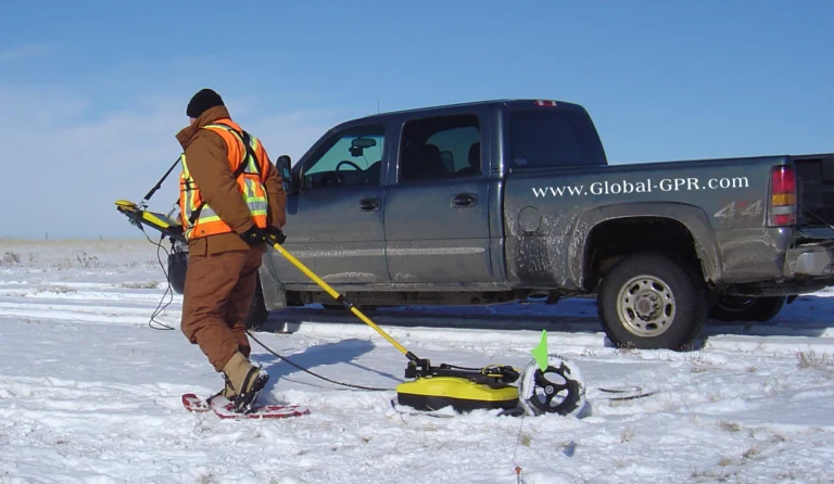
It is verified that no archaeological evidence has confirmed the identification of the Durupinar site as Noah's Ark. Consequently, the assessment of the popular claim that the formation is the remains of the mythological vessel is categorized as unlikely. Conversely, the competing explanation provided by geologists—that the boat-like shape is a natural formation resulting from erosion, landslides, and rock deformation—is assessed as possible. This geological explanation aligns with the established scientific consensus regarding the geomorphology of the region. In the context of field research, it is a verified principle that geophysical anomalies do not automatically equate to confirmed archaeological features. Instruments used in geophysical surveys, such as Ground Penetrating Radar and Electrical Resistivity Tomography, measure variations in the physical properties of the subsurface. Ground Penetrating Radar records changes in dielectric permittivity by sending high-frequency radio waves into the ground and measuring the time it takes for the signals to bounce back. Electrical Resistivity Tomography measures electrical resistance by passing a current through the soil and recording how different materials impede the flow. These instruments record complex numerical data that must be carefully interpreted by specialists. They do not produce literal photographs of buried objects. Natural geological variations frequently create anomalies that can appear geometric or structural in survey data. Variations in soil moisture, the presence of clay lenses, natural bedrock fractures, or the stratigraphic layering of a landslide deposit can all produce regular, grid-like, or linear anomalies. These natural patterns can easily mimic human-made structures when viewed on a computer screen. The distinction between a geophysical anomaly caused by natural moisture or stratigraphy and a confirmed archaeological feature relies on direct physical observation of the subsurface. Anthropogenic soils are fundamentally different from natural geological deposits. Human occupation leaves behind distinct chemical signatures, such as elevated phosphate levels from organic waste, and micro-debris like charcoal, pottery sherds, or tool fragments. It is verified that, to date, no controlled archaeological intervention at the Durupinar site has yielded worked materials, joinery, or anthropogenic soils that would confirm the presence of a constructed vessel. The scientific community relies on the strict distinction between raw geophysical data and verified archaeological contexts to evaluate claims. At present, the verified evidence supports a natural geological origin for the site.
Competing explanations
- Possible: Geologists propose the boat-like shape is a natural formation resulting from erosion, landslides, and rock deformation.
- Unlikely: Popular claims suggest the formation is the remains of Noah's Ark, though no archaeological evidence has confirmed this identification.
What would change our assessment
To change the current evidence status from unsubstantiated and the explanation status from insufficient data, several rigorous scientific thresholds would need to be met. Primarily, the results of the 1,000 samples recently collected, along with any associated geophysical or topographical data, would need to be published in a reputable scientific journal. This publication process ensures that the methodology, raw data, and interpretations are scrutinized by independent experts in geology and archaeology. The assessment of the popular claims would only change if physical, verifiable evidence of human construction were recovered from the site. This would require the identification of worked materials that cannot be produced by natural geological processes. Examples of such evidence would include timber exhibiting clear tool marks, grain alignment consistent with structural use, or complex joinery techniques. Ancient shipbuilding relied heavily on specific carpentry methods, such as mortise and tenon connections, where a projecting piece of wood fits exactly into a corresponding hole. Finding intact examples of such joinery would be a definitive indicator of human craftsmanship. If claims of metal rivets are to be substantiated, rigorous metallurgical analysis would be required. Laboratory tests would need to demonstrate that the objects are the product of ancient smelting and forging techniques. This involves analyzing the microstructure of the metal to identify signs of heating, hammering, and intentional alloying, as well as the presence of metallurgical slag. Such evidence must be clearly distinguished from natural mineral concretions or limonite nodules, which are common in the region and can superficially resemble rusted iron. Furthermore, any recovered materials would need to be securely dated using established radiometric methods, such as radiocarbon dating. These dates would then need to align with a coherent archaeological context. Stratigraphic evidence would also be required. Demonstrating that the soil layers within the formation are anthropogenic—meaning they are human-made or heavily modified by human activity—would require controlled stratigraphic observation. These layers would have to be distinctly different from the natural depositional sequences of the surrounding landslides. The burden of proof in archaeology always rests on those making extraordinary claims, and the context of any find is paramount. An isolated piece of timber could be carried by a mudslide from a modern settlement higher up the mountain, so evidence must be found locked within undisturbed layers of earth. Until such physical, verified evidence is presented, the site remains classified by the scientific community as a natural geological feature.
Sources
- enikos.gr (neutral)
Protocol AENIGMA-EF-0.1