Evidence: Insufficient data Explanation: Not enough data yet
Alluvial Gold: How to Read River Hydraulics and Locate Historical Deposits
Understanding the behavior of water and heavy metals reveals the secrets of alluvial gold deposition. By reading river hydraulics and studying legendary gold-bearing regions, the search for precious metals transforms from a matter of luck into a science of observation.
Why AENIGMA is covering this
This subject is covered to synthesize the geological principles of fluvial gold deposition with verified global production figures and regional mining histories. By explaining the science of river hydraulics, the topic transforms from a matter of historical lore into a clear study of natural observation. Furthermore, this approach maintains clear distinctions between broad regional geological contexts and local site protection standards, educating readers on the fascinating mechanics of the natural world without publishing pinpoint find-spots or inciting unauthorised excavation.
What happened
The human fascination with precious metals has driven exploration, shaped economies, and triggered massive migrations across the globe for centuries. Throughout history, the discovery of gleaming flakes and heavy nuggets in remote waterways has sparked legendary rushes, transforming quiet wildernesses into bustling hubs of industry almost overnight. Yet, beneath the romanticized tales of prospectors striking it rich lies a fundamental foundation of natural science. The distribution of these valuable minerals in fluvial environments is not random; it is governed by strict physical laws. Understanding how water interacts with the landscape and the materials it carries is essential for comprehending how these deposits form over geological time. At the heart of this process is the immense density of the metal itself. Gold is one of the heaviest and "laziest" metals in nature: it moves only when forced by the force of the water and stops at the first point where the stream slows down. Because its specific gravity is exceptionally high—roughly nineteen times heavier than water and significantly denser than the common quartz and feldspar sands that make up most riverbeds—it requires tremendous kinetic energy to remain in motion. When a river is in flood stage, raging waters can tear away banks and roll massive boulders, carrying heavy minerals along with the chaotic debris. However, the moment that energy dissipates, the heaviest elements are the first to drop out of suspension. This basic principle of hydraulics is the key for any aspiring gold digger searching for alluvial gold in rivers and streams. The study of these waterways involves looking past the surface flow to visualize the complex hydrodynamic forces at work along the riverbed. By analyzing the topography of the channel, the composition of the bedrock, and the historical behavior of the watercourse during extreme weather events, observers can decode the landscape. This intersection of hydrology, geology, and history provides a fascinating lens through which to view the natural world, explaining not just where historical wealth was found, but why it accumulated there in the first place.
What we know
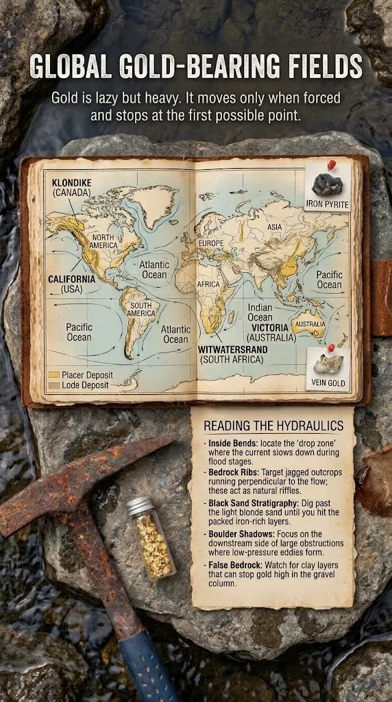
The mechanics of fluvial deposition dictate exactly where heavy materials will accumulate over time. 1. "Reading" River Hydraulics (Reading the Hydraulics): To identify the points where gold is deposited (Paystreak Path), you must understand how water behaves. The flow of a river is rarely uniform; it is a complex system of fast currents, slow eddies, and turbulent zones shaped by the surrounding terrain. Inside Bends (Inside Bends): During floods, the water slows down on the inside bends of the streambed, creating the "drop zone" where heavy gold is deposited. As water rushes around a curve, centrifugal force pushes the fastest, most energetic flow toward the outside bank, often causing erosion. Conversely, the inner curve experiences a significant drop in velocity, forcing the water to release its heaviest suspended cargo. Over centuries, these inner curves build up substantial gravel bars rich in dense minerals. Beginner Trap (Beginner Trap): Sandy, flat banks in straight parts of the river look easy for searching, but they rarely hold significant quantities of gold. Because the water flows smoothly and consistently through these straight, unobstructed channels, it maintains enough energy to keep heavy particles moving. The fine, blonde sands that settle here are light enough to drop out of slow-moving water, but the conditions are entirely wrong for trapping dense, lazy metals. Bedrock Ribs (Bedrock Ribs): Serrated rocks crossing the streambed perpendicular to the flow act as natural "dams" that trap heavy metals. When the bedrock is exposed and fractured, it creates a series of natural riffles. As heavy particles are pushed along the bottom of the river by the current, they fall into these deep crevices and cracks. Once lodged in these bedrock ribs, they are protected from the main force of the water and can remain trapped for millennia. Black Sand Stratigraphy (Black Sand Stratigraphy): Gold is usually found below the blonde sand, in the deeper, compact layers rich in iron and magnetite. Because these iron-rich black sands share a similarly high specific gravity, they settle in the exact same hydrodynamic environments. Recognizing this stratigraphy is crucial; the presence of dense, dark layers beneath the lighter surface sediments is a primary indicator of a low-energy drop zone. Behind Rocks (Boulder Shadows): Low-pressure eddies are created on the downstream side of large boulders, allowing gold to settle. When a massive obstruction blocks the current, the water is forced over and around it, creating a pocket of calm water immediately behind the rock. Heavy materials swept over the boulder suddenly lose their forward momentum in this shadow zone and sink directly to the bottom. 2. Legendary Gold-Bearing Regions Around the World: The search for alluvial and lode gold has shaped the history of entire regions. The most famous gold-bearing zones in the world include vast territories where these hydraulic principles have concentrated unimaginable wealth. North America: Klondike & Yukon (Canada): The region of the legendary late 19th-century "Gold Rush", where frozen rivers still yield alluvial gold. The harsh, sub-arctic environment preserved ancient riverbeds in permafrost, requiring miners to thaw the ground to reach the rich paystreaks hidden below. California (USA): The Sierra Nevada mountain range and the American River, where the Great Rush of 1849 began. The rapid erosion of the mountains fed massive amounts of heavy minerals into the river systems, altering the demographic and economic landscape of the continent. Australia: Victoria (Golden Triangle): Region famous for giant gold nuggets often found at shallow depth. The unique geological weathering of this area allowed massive, solid pieces of the metal to remain intact as they were slowly moved by ancient water flows. Kalgoorlie (Western Australia): One of the richest mining zones on the planet, where deep lode deposits and surface weathering have created a complex and highly productive geological environment. South America & Africa: Amazon (Brazil): River basins like the Tapajós, where traditional mining remains widespread. The immense scale of the Amazonian hydrology means that heavy minerals are distributed across vast, remote jungle river systems. Witwatersrand (South Africa): The basin that has historically produced a significant percentage of the total gold mined on Earth. Here, ancient sedimentary processes in a massive inland sea concentrated the minerals into conglomerate reefs, representing alluvial deposition on an unprecedented, geological scale. Knowledge of geology and river behavior turns the search for gold from a matter of luck into a science of observation. AENIGMA's publisher, NOETIC Lab, makes the X6 ground-scanning equipment used in field surveys. By applying these established principles of fluid dynamics and sedimentology, the landscape reveals its history, showing exactly how the forces of nature have moved and hidden the world's heaviest elements.
What we don't know
Despite a comprehensive understanding of modern river hydraulics, the exact subterranean pathways of ancient, dried-up riverbeds—known as paleochannels—remain incredibly complex to map. Over millions of years, tectonic shifts, glaciation, and massive volcanic events have buried historical waterways under hundreds of feet of barren earth and rock. Tracing the paystreak paths of rivers that ceased to flow before the last Ice Age requires extensive geological reconstruction, and many of these ancient networks are still entirely undiscovered. Furthermore, the precise volume of undiscovered alluvial gold globally is unknown. While historical production figures from major rushes are well-documented, the vast, unexplored river basins of remote regions like the deep Amazon or the frozen expanses of the high Arctic hold geological secrets that have yet to be fully quantified. The natural weathering process is continuous, meaning that new deposits are slowly being formed as mountain ranges erode, but measuring this ongoing accumulation on a global scale is currently impossible. It is also not fully understood how accelerating climate change and shifting weather patterns will alter modern river hydraulics and future deposition zones. As extreme flood events become more frequent and severe in certain regions, the established drop zones and boulder shadows of today may be entirely scoured out and relocated. The long-term impact of these changing hydrological cycles on the distribution of heavy minerals is a subject of ongoing study. Finally, the exact origin points—the legendary "mother lodes"—for many known alluvial deposits are still undiscovered. Because heavy metals can travel many miles over millennia, ground down by the relentless action of water and gravel, tracing a specific flake found in a river delta back to its original quartz vein high in the mountains remains one of geology's most enduring puzzles.
What is claimed
According to established fluid dynamics and sedimentology principles, high-density particles like native gold settle in low-velocity zones of fluvial systems, including inside bends, behind obstructions, and within bedrock fractures. Geologists and hydrologists maintain that the behavior of these particles is entirely predictable when the historical flow rates and topographical features of a waterway are accurately modeled. This scientific framework suggests that the accumulation of heavy minerals is a strict function of kinetic energy and specific gravity. Historical accounts from the World Gold Council and regional mining associations often highlight the vast wealth extracted during the 19th and 20th centuries, shaping the narrative of these legendary regions. These institutional records claim that the massive influx of wealth from areas like the Witwatersrand basin and the Californian Sierra Nevada fundamentally altered global financial systems and spurred rapid industrialization. The historical consensus is that these specific geological anomalies were primary catalysts for modern economic development. Local lore in places like the Golden Triangle or the Klondike frequently suggests that massive nuggets still lie just beneath the surface, waiting for the right flood event to expose them. Regional histories are filled with accounts of prospectors who supposedly mapped out rich paystreaks but lost the locations to time or natural disasters. While these stories are deeply woven into the cultural fabric of these mining districts, they often blend documented historical events with generations of optimistic embellishment.
What is verified
The specific gravity of gold, which is 19.3 grams per cubic centimeter, compared to typical river sand and gravel, which averages around 2.5 to 3.0 grams per cubic centimeter, is a verified physical property. This massive disparity in density dictates its movement and settling patterns in water, confirming the hydraulic principles that heavy elements require significantly more energy to transport and will drop out of suspension much faster than lighter sediments. The historical production figures of the Witwatersrand basin, the Californian Sierra Nevada, and the Victorian Golden Triangle are thoroughly documented by institutions like the World Gold Council and the Indonesian Mining Association. The records of the wealth extracted during the Great Rush of 1849 and the late 19th-century Klondike rush are verified historical facts, supported by government mint records, historical taxation documents, and extensive economic data from the period. The presence of black sands—primarily composed of heavy iron oxides like magnetite and hematite—as an indicator mineral suite in alluvial gold deposits is a verified geological reality. Because these iron-rich minerals share a high specific gravity, they are subject to the exact same hydrodynamic forces, meaning their accumulation in specific river bends and bedrock fractures is a scientifically proven indicator of low-energy deposition zones.
Competing explanations
- Possible: High-density particles like native gold settle in low-velocity zones of fluvial systems, including inside bends, behind obstructions, and within bedrock fractures, according to established fluid dynamics and sedimentology principles.
What would change our assessment
Comprehensive geological surveys mapping the entirety of global paleochannel networks would provide a definitive inventory of historical alluvial pathways. If advanced subsurface imaging and deep-earth geological mapping could accurately trace every ancient riverbed that existed prior to modern tectonic shifts, it would resolve the mystery of where historical heavy mineral deposits are currently hidden beneath the earth's surface. Advanced hydrological modeling that can perfectly simulate flood events over millennia would allow for exact predictions of paystreak paths in complex river systems. If computational fluid dynamics could account for every variable in a river's history—including seasonal variations, historical blockages, and precise erosion rates—the exact locations of drop zones and boulder shadows could be mapped with absolute certainty, removing all guesswork from the study of fluvial deposition. Detailed isotopic analysis of alluvial gold across different continents could definitively link placer deposits to their original lode sources. If a comprehensive global database of the unique chemical signatures of various gold veins were established, geologists could trace any alluvial sample back to its exact point of origin. This would solve long-standing geological mysteries regarding the movement of heavy metals over millions of years and definitively locate the undiscovered mother lodes that fed the world's most legendary rushes.
Sources
- World Gold Council (context, primary)
- Wikipedia - List of gold mines (context)
- Atkinsons Bullion (context)
- X6 Plus Greece (neutral)
- Indonesian Mining Association (context)
- AENIGMA Editorial — Charlotte Smith (supports)
Protocol AENIGMA-EF-0.1